How much can you fit into one weekend? Not sure, but we gave it a good shot. Starting out on a nice Saturday morning we had our backpacks on and were ready for what we knew would be a good slog uphill. With no water available on the walk, we ended up taking 12 litres of water, 2 litres of milk (frozen) and 100 ml of wine (for me). This put Kerrie's pack at 18.5 kg and mine 22.5 kg.
After heading down the gravel road for about 800 meters, before arriving at a gate, we headed down an old disused road, which is blocked off with a pile of dirt. Shortly after, there is an old timber bridge, in the picture below.
After another 200 meters, there is a cairn that signals the turn west and up we go.
 |
| Cairn marking the turnoff. |
For about 2.5 km it goes up with next to no relief. The track is vague at times, but following the spur, it would be almost impossible to get lost. The last 500 meters is the steepest pinch to the top.
 |
| It is a long 2.5 km up. |
It took us about 2 hours to get up the hill with our heavy overnight packs, but with only daypacks, it could probably be done in about 1 hour.
We were well and truly warmed up when we got to the intersection that is the three ways between Mt Roberts and Mt Superbus. Not sure whether this is an official camping site, but it would be a good overnight spot to camp to do the Lincoln Bomber Plane Wreck and Lizard Point over two days, like us. We had already booked Mt Superbus saddle campsite and the plan was to drop our backpacks there and head off with a day pack on the return journey to the Lincoln wreck.
After the initial uphill, Mount Superbus (not pronounced as spelled i.e. not Super Bus) was a breeze. Although there were no views, it still was a pretty cool place. The logbook also doubled as the only Geocache in the area.
 |
| Mount Superbus log book and Geocache |
 |
| Top of Mount Superbus |
About 500 meters past Mount Superbus we found what we assumed must be the campsite. We set up our tent had some well-deserved coffee and lunch, packed our daypack and headed out again towards the Lincoln plane wreck.
 |
| Awesome campsite |
We followed a vague footpad and fluoro tape along the ridge through some haunting rainforests, which made us feel special to be part off. It was awesome to be out there with no human sounds, only the light breeze through the trees and birdlife. I particularly liked the number of people we had met so far i.e. 0.
 |
| Beautiful settings |
Just before heading down the ridge towards the Lincoln wreck, we came across another campsite which is also pretty nice.
 |
| Lincoln wreck campsite |
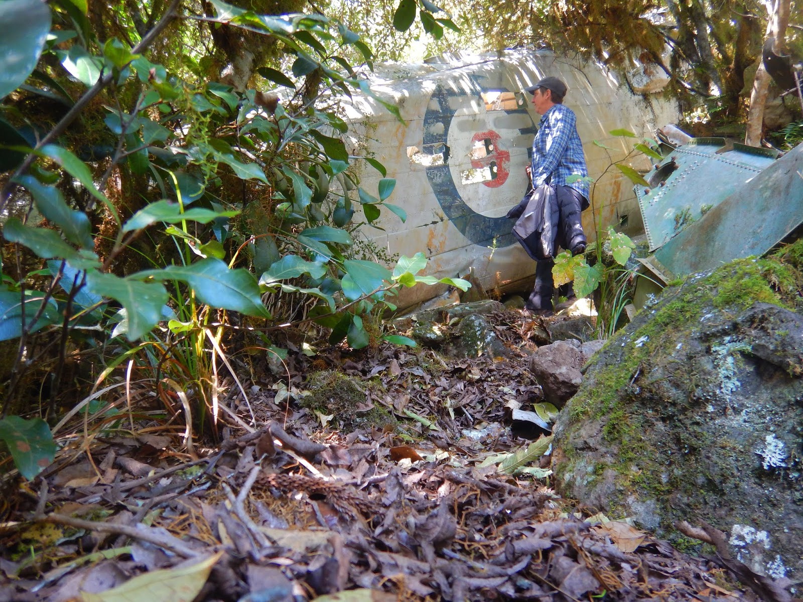
The Lincoln Bomber Wreck is amazing with a lot of the plane still present. This is much better than the "Stintson Wreck", which only has a few bits of metal left.
 |
| Lincoln wreck plaque |
 |
| Don't know what it is but maybe a wing |
 |
| Still, a lot left of the plane |
 |
| Fuselage. |
 |
| Still well preserved. |
The return trek from our campsite to the Lincoln wreck is about 6km and took us 2.5 hours, including looking around the wreck.
By the time we got back to our campsite, we were pretty knackered and I enjoyed my little wine before cooking our gourmet dinner.
 |
| Dinner |
It started cooling down fast and we decided to call it quits and were in the tent by 17:15 and I was asleep by 17:16 apparently. Kerrie was up for some time listening to my amazing snoring. Kerrie is very privileged, not many people have the chance to hear such beauty.
After an amazing 13 hour sleep (a bit less for Kerrie) we packed up our camp and headed back to the crossroads where we left our backpacks, once again for an easier day walk.
A small opening in the forest, about 1 km after the crossroads, provided a magnificent view of the Steamers, which is another walk/climb on our bucket list.
 |
| View of the Steamers |
Following along the ridge and a bit of undulating (read - steep at times!) walking we bagged Mount Roberts.
 |
| Top of Mount Roberts |
The path onwards provided us with more spectacular foliage and we had to do a bit of bush bashing.
 |
| Huge plants to navigate through |
And some scrambling, although not very dangerous.
 |
| Bit of scrambling |
Eventually, we arrived at the Lizard Point campsite which is awesome and could probably hold up to three tents.
 |
| Lizard Point campground |
Lizard Point itself (only a few hundred metres further on) turned out to be one of the most spectacular places we have seen, providing views that were just incredible.
 |
| Top of the day on Lizard Point |
 |
| Views from Lizard Point |
It was worth a good rest and we enjoyed lunch and a bit of a lay down on top of the world. We felt like we were in heaven and soaked up the warm sun out of the wind.
 |
| Flat out like a lizard |
But it was time to make our way back and when we strapped on our backpacks we were glad that they were not as heavy as yesterday.
 |
| Picking up the packs for the hike down |
The scramble down was interesting with a lot of slipping and sliding, but it was a lot easier than the way up and it only took us about 1 hour for the descent to the track below. I am glad to report that this was another magnificent weekend in the bush that Kerrie organised. Ah yes, and during the two days hiking, we didn't see another person!
Length of walk
25 km return approx over two days.
Time
2 days
Best Time to do
Cooler months, with no rain on the day as it would be very dangerous.
Difficulty
Medium to hard. Although there is a vague footpad and tape marking the track a bit of hiking experience is required to do this track.
There is pretty good mobile coverage on most of the track (we have an Aldi mobile package that uses Telstra towers).


No comments:
Post a Comment