Being the first day of school holidays and Covid19 restrictions eased, there are people everywhere. As I am somewhat allergic to large numbers of people, Kerrie had to do some intensive research for a 4-day cycle tour.
The result: 4 days around Yarraman, but with only a vague idea where we would camp.
With the plan in place, bikes packed we arrive at Yarraman police station where we had a chat with a local policeman, who is more than happy for us to park in front of the station. Apparently, quite a few people use this car park as their Brisbane Valley Rail Trail (BVRT) base.
Although our trip starts at the rail trailhead, this is not where we are heading. At the trailhead, we come across this awesome old tanker, probably used to transport beer (just an unqualified opinion).
Heading out of Yarraman we are on quiet country roads and the weather seems to be on our side.
Soon we turn onto the old stock route which now is used to link the BVRT and the Kilkivan to Kingaroy rail-trail. For most of the way, the stock route is an easy-going gravel road. With only 1 to 2 km of rougher road in between. But nothing technical.
We even found a nice waterhole and some not so old historical automobile memorabilia. With temperatures being well below 20 degrees Celcius, we decided against swimming and climbed the car wreck instead.
Shortly before Nanango, we not only encounter our first moving car, but also our first dragon. Luckily we didn't have to fight either.
After leaving Nanango, where we had lunch and filled up water in a local park, we climbed some impressive hills but also were rewarded with a 3km downhill run. Unfortunately, the downhills are over so much faster than the uphills.
Not long after merging onto Western Branch Road (ie, the Western Branch of the Brisbane River), we came to Mt Stanley State Forest, where we found a nice grassy spot to camp under a tree well away from the road.
It was extremely peaceful and we enjoyed a relaxed afternoon and dinner before heading to bed early (temperature dropped dramatically).
Set for a nice quiet sleep we were awoken around 9:30pm by gunshots. Hoping not to be mistaken for game, we stayed in our tent and listened to further shots that seemed to be further away each time. Not long after all was quiet again and we fell back into our slumber.
After an early start the next morning, we came across this fine-looking stag. Luckily he escaped last night's hunters.
It is odd crossing the beginnings of the Brisbane River, which is nothing more than a little creek up here. Although we started at crossing number 26 yesterday, this is the first one we took a photo of.
Most crossings contain a bit of water, but some are actually dry.
Last night's shooters either can't read or just ignored this sign.
Meandering through a blue sky and golden grass scenery we headed leisurely downhill towards Linville.
Who says we don't have seasonal trees in Queensland, the hills were dotted with these yellow trees that contrasted the landscape beautifully.
This is no ugly duckling, this majestic swan decided to nest in the Brisbane river right beside the road. At least she won't be lonely.
As with most of our outings, we came across some unusual letterboxes. It took us a while to determine that this was not a zebra, but a cow. In the end, it was the horns and the cowbell that gave it away!
We made it to Linville as did hundreds of other people. The free campground was full of caravans and I am only happy that we don't have to spend our night here. Especially with the pub right across the road pumping out rock n roll.
The next leg of our journey is on the BVRT towards Benarkin and Blackbutt. We are twisting our way slowly up the range, but rail-trails are never steep as trains apparently don't like hills. I am always amazed at how this railway line was built and it is good to see that it gets used once again. Sometimes I even sound like an old steamer grinding my way uphill.
About 10 km outside of Benarkin we find this shelter, complete with water tank and toilets. It seems camping is allowed here (at least there is nothing saying that you can't) and we decided to pitch up our tent.
After a night without gunshots, we are back in the saddle heading for Benarkin.
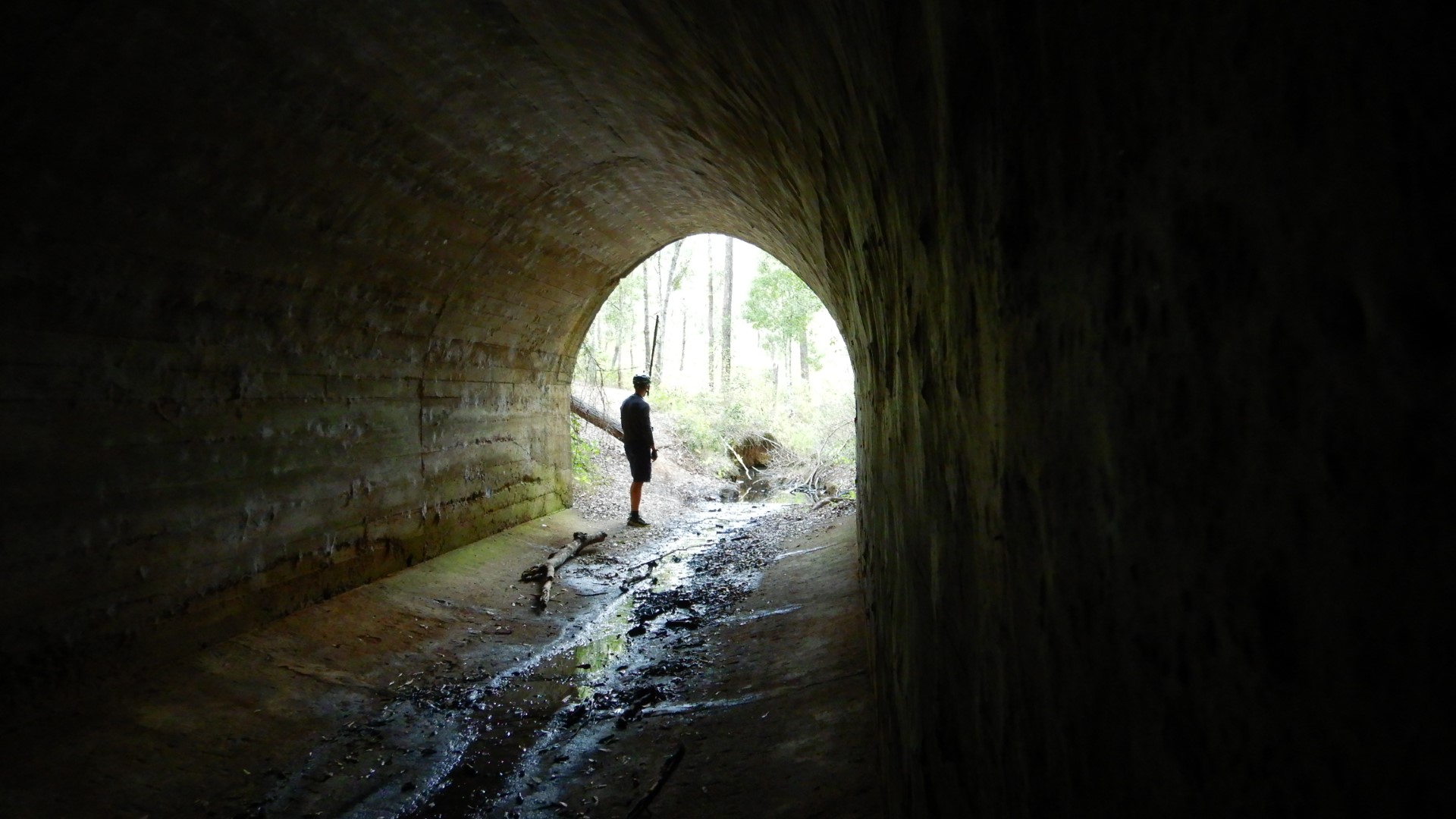
To our surprise, we found this fantastic culvert that was hand-built by the railway workers of old. It is in amazingly good condition.
Along the rail-trail, we came across several of these odd-looking contraptions. Finally, we found a sign explaining that these were "dogs" that connected the rail carriages to each other.
On arrival in Benarkin, we nearly decided to take advantage of the free showers, but as we were only one hour into our day we kept on cycling towards Blackbutt.
Blackbutt Station houses a free museum that provides a lot of historical information about the area. The complex is lovingly looked after by a number of volunteers.
Heading towards Yarraman, after we had hot chips for morning-tea (we couldn't get any pastries as there was a 30-minute line up at the bakery), we crossed several of these grids, which are an awesome alternative to constantly opening and closing gates.
Another past station site and this is giving me ideas for a new bike storing solution.
Soon we turn off the rail-trail and head back onto country roads that cross some creeks that call for reflection.
And provide a nice place for lunch.
It is getting close to find another campsite, but not before we check out the idyllic Yarraman cemetery and confirm that water is available if we needed any. It is a good trick we learned a while back that all cemeteries have a water supply.
Not long after we do some bush bashing and find a clearing in the pine forest, once again well away from any roads or civilisation.
After another 12 hour sleep, we are commencing our last day, going past some iconic Australian structures and as for most of the last four days, deep blue skies.
Yarraman state forest is a beautiful mixture between pine plantations and native forests...
...with some nice uphills. But the tracks are in perfect condition.
If we had been a few weeks later we could have enjoyed some watermelons that were growing beside the road. Ah well, we leave these for someone else.
Unfortunately, all good things come to an end, but we are well rejuvenated to face civilisation and work again. We head into Yarraman after four days of cycling and are amazed that we didn't encounter any flat tyres (after our last episode of three flats in 24 hours).
Although we love the rail-trails this outing was a nice deviation from the normal, using some of the area's most beautiful country roads.


No comments:
Post a Comment